No matter where you are in Alabama, you will be treated to fabulous bird watching. Although there are several distinct geophysical areas in Alabama, for birding purposes, we can divide the state into four regions, each with its own collection of birds. Before we look at those regions, let’s look at one other feature that is extremely important for birds and birding.
In addition to hundreds of creeks and small rivers, Alabama is blessed with four major river systems that offer habitat for a whole flock of bird species. These are the Chattahoochee, which forms much of the boundary between Alabama and Georgia, the Tennessee, which loops down across the top of the state, the Coosa-Tallapoosa-Alabama system, which flows from northeast to southwest across central Alabama, and the Warrior-Tombigbee, which flows from north-central and west Alabama southward down the west side of the state. The latter two systems culminate in the Tensaw Delta and flow into the north end of Mobile Bay.
Gulf Coast Region
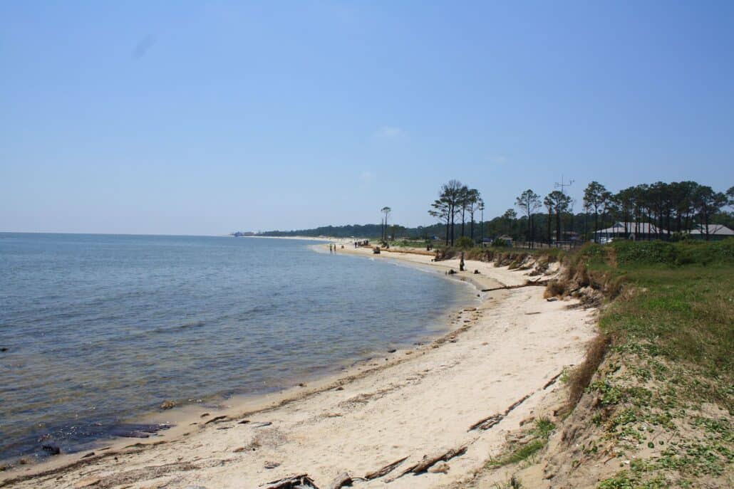
The two southernmost counties, Baldwin and Mobile, include the Tensaw Delta and all of Alabama’s more than 600 miles of tidal coast line, and comprise the Gulf Coast Region. Mobile is the largest city in the region, and lies on the northwest edge of Mobile Bay. The battleship USS Alabama is permanently moored here and the Battleship Park is one of only a few good places to see black-necked stilt. Many birds breed in the gulf coast region and it is host to many more during migration and winter. Virtually every bird common to the state has been seen here. Much of the shoreline has been “developed,” so birding access is limited but not difficult.
The terrain of this small region is quite diverse. Mobile Bay separates the southern halves of the counties. Dauphin Island, a barrier island, lies off the southern tip of Mobile County, and on the western side of the bay. As previously noted, it is a migrant hotspot in spring and fall. It is a reliable spot for sea- and shorebirds, including American oystercatcher, black skimmer, terns, gulls, brown and American white pelicans, and ruddy turnstone. There are many saltwater marshes and tidal flats near the coast, particularly on the west side of the bay, and sandy-floored woods of scrub oak and pines.
Fort Morgan lies at the end of a peninsula on the east side of the mouth of Mobile Bay, opposite Dauphin Island. A ferry crosses between the two every hour and a half, shortening the driving time by about two hours and offering some interesting seabirds too. The road to Fort Morgan passes the Bon Secour National Wildlife Refuge and is reliable for osprey and peregrine falcon during migration.
Once you leave the immediate beach area and cross north over the Intercoastal Waterway, Baldwin County has large flat agricultural fields which offer forage for pipits, shorebirds, and sparrows. The edges of these fields are particularly good habitat for wintering sparrows, and orange-crowned warbler. Many low places have stands of carnivorous pitcher plants.
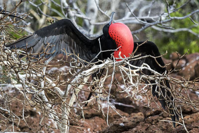
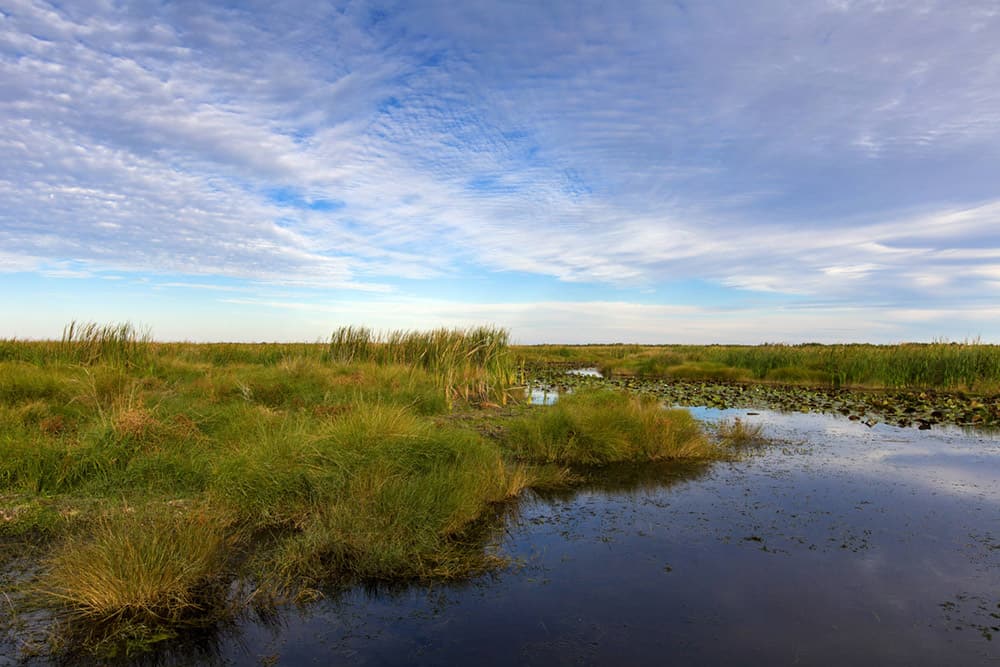
The northern half of the region is rolling hills divided by the Tensaw Delta. The Delta, while landlocked, is truly a delta built up between higher ground on either side. It is 450 square miles of swamp, and it provides exceptional habitat for many ducks, herons, egrets, rails, anhinga, white ibis, owls, hawks, osprey, Mississippi and swallow-tailed kites, and warblers. Much of the delta is inaccessible except by boat, but any birder who makes the effort to bird there will be richly rewarded. A few large pine savannahs survive east of the delta and are good habitat for Bachman’s sparrow.
The gulf coast region is alive with birds and bird songs during breeding season, which starts early and lasts well into summer. Additionally, migration can be an exciting and even mind-boggling event given the right weather patterns.
Coastal Plain
The southern half of the state—less the gulf coast region—is part of the Coastal Plain, which stretches across several southern states. The Coastal Plain extends northward to the fall line, where navigation on Alabama’s many rivers becomes impossible. This line runs roughly from Phenix City in the east to Tallassee and Wetumpka, and then northwest to Tuscaloosa.
The Coastal Plain is relatively flat rolling terrain, but with plenty of surprises. This was once home to many large antebellum cotton plantations, and it still has many cotton fields, cattle farms, and timber plantations. Catfish and crawfish farming have increased in recent years, and these farms are good places to look for water and wading birds. Many of these farmers are birder friendly, and will allow you to enter for a better look, but it’s imperative that you obtain permission first.
Except for the riparian corridors rich in hard woods along the many rivers, the timber is primarily pine, particularly in the southern part, where there are a few large remnants of southern longleaf pine forests. These offer one of the few places to see the endangered red-cockaded woodpecker. The coastal plain and gulf coast regions are home to thousands of southern magnolias, and their fragrance in late spring can make one forget the modern world around you.
The riparian habitat is home to most of the state’s Mississippi and swallow-tailed kites. It also offers extraordinary habitat for many warblers, swallows, raptors, wood thrush, yellow-billed cuckoo, and other passerines. Away from the rivers and streams, the relatively flat terrain offers many areas of standing water that attract wading and shore birds in season, as well as open-country birds such as meadowlarks. During late summer, as wood storks disperse northward from their breeding grounds, primarily in Florida, they can often be seen near small stock ponds and shallow standing water.
The Coastal Plain includes Dothan and the Wiregrass area of southeast Alabama, so named because of the sturdy grass that was common before agriculture replaced most of it. The Chattahoochee River is the eastern boundary, and includes the Eufaula National Wildlife Refuge, which is alive with waterfowl of every sort during the winter. Hunting is allowed here, so do not go behind any closed gates, even on foot, without checking first with the refuge office. All of southeast Alabama is good habitat for common ground-dove, although they are rather hard to see most of the time.
The Coastal Plain also includes a swath of black belt, named for its fertile soil, which generally includes Tuskegee, Montgomery, the largest city of the region, and Selma. As you go into the northwest section of the plain, the soil becomes limestone and shale, and the trees tend more toward eastern cedar and pine. The Coastal Plain is relatively less populated with birds than the rest of the state but is still home to many breeding blue grosbeaks, indigo buntings, great crested flycatchers, northern bobwhites, red-tailed and red-shouldered hawks, and cattle egrets, as well as many other passerines. One fairly new bird to the region, and expanding rapidly to the north, is the Eurasian collared-dove, which thrives in urban settings.
Perhaps the signature bird of the region is the brown-headed nuthatch, which travels in small flocks often with chickadees and titmice. It lives almost exclusively in natural-growing pine trees.
Mountain Region
Above the fall line the terrain becomes noticeably more hilly and rugged, with exposed rocks and more hardwoods than pines. This is probably the most scenic region of Alabama. The highest point in the state, Mount Cheaha, elevation 2,407 feet, lies in this area, and is one of the southernmost breeding areas for black-throated green warbler and ovenbird. The annual temperatures tend to be slightly cooler than the coastal plain, and the terrain is much more varied, so you get a more diverse assortment of birds which begins to resemble northern states. Buck’s Pocket State Park and Little River Canyon Natural Preserve offer both spectacular scenery and a wide mixture of birds.
Birmingham is the largest city in the region, which also includes Opelika, Anniston, Gadsden, and Cullman. The region has a triangular piedmont in the southeast portion. As you travel toward the northwest, you encounter a series of high hills and deep valleys as you cross the southern end of the Appalachian Mountains. There is also a relatively high and flat plateau known as Sand Mountain. Both of these mountain zones run northeast to southwest. The region is bounded on the northeast by the Tennessee and Georgia lines and by the Tennessee River Valley in the northwest.
Hardwoods predominate, and agriculture turns toward smaller operations. Mountain laurel blooms in May, and can be beautiful. Soaring birds such as turkey and black vultures and hawks use the updrafts created by the hills and valleys. One very relaxing way to enjoy both the beauty and soaring birds of this region is to dine in the lodge restaurant atop Mount Cheaha. There you can see for miles, eat good food, and watch the birds, many of them soaring at or below eye level.
Both whip-poor-will and chuck-will’s widow can be heard at night, and black-and-white warblers forage on the tree trunks and limbs. Both the golden-crowned and ruby-crowned kinglets winter here and can be seen foraging in their frenetic manner. There are national forests, the Pinhoti Trail, a 110-mile hiking trail through exceptional habitat, and the Sipsey Wilderness Area, where warbler neck is inevitable in the spring. The Sipsey River Swamp, a different location from the wilderness, also offers terrific warblers during spring migration.
Alabama’s newest wildlife refuge, the Mountain Longleaf National Wildlife Refuge, which is part of what was once Fort McClellan, is in this region.
Tennessee Valley Region
The extreme northeast corner of Alabama is very difficult to categorize; it is clearly part of the Mountain Region, but the Tennessee River, which by definition flows through the Tennessee Valley, enters the state through this region. To minimize the confusion, we will generally define the Tennessee Valley Region as the northwest portion of Alabama plus the actual Tennessee River and associated valley as it runs through the Mountain Region. The Tennessee Valley Region is characterized by moderately large cotton, hay, and grain fields on mostly flat to gently rolling hills. The forests are generally small deciduous trees with a mixture of pines.
The Tennessee Valley Authority dammed the river in the 1930s, creating a virtual paradise for fisherman and birders. Lake Guntersville, the first Tennessee River lake in Alabama, lies north of Gadsden amidst the Mountain Region, and is one of the best places to see bald eagles. There is the occasional golden eagle, so pay close attention to all eagles, as immature bald eagles are easily confused with golden eagles. As the river turns back northwest, a series of dams has created almost a continuous lake well up into Tennessee.
The Wheeler National Wildlife Refuge lies near Decatur. It has a wonderful, enclosed, heated viewing building that overlooks an extremely popular waterhole for ducks and geese. In recent years the refuge has been the winter home for hundreds of sandhill cranes. Wilson Lake is next, and the shoals below Wilson Dam are the best place in Alabama to see a variety of winter gulls and terns. Pickwick Lake, like Guntersville, is known for its wintering eagle population.